
We saw some amazing cities in the world that are lost and no longer known to the rest of the world. They have either been abandoned or have been completely eradicated by nature’s wrath in the first part of the blog sequel, “Explore 25 Lost and Forgotten Cities of the World-Part 1.” As we said in the first part and as the name suggests, we’ll be talking about 25 of these cities. In this episode, we’ll visit 7 more interesting places that have disappeared or are no longer in use.
Let’s start exploring!
8. Jordan’s Petra is a Lost city hewn out of the rock

Petra, once the Nabataean capital, was abandoned by the Romans in the fourth century AD and not rediscovered until 1812. During its heyday, this historic city was an important stop on the silk and spice trade routes that connected Asia with Arabia and the West. Even though Petra was cut right into bright red, white, pink, and sandstone cliff faces, it was “hidden” from the rest of the world for hundreds of years.
Petra, presently in the southwestern part of the Hashemite Kingdom of Jordan, was the bustling commercial center and capital of the Nabataean empire from roughly 400 B.C. to A.D. 106. It is situated among harsh desert canyons and mountains.
As centuries passed, the city remained deserted and in disrepair. It wasn’t until the early 1800s that a European tourist posed as a Bedouin to enter the secretive region and found the lost glory.
Petra Archaeological Park, a UNESCO World Heritage site since 1985, was also named one of the new seven wonders of the world in 2007. Before being defeated and incorporated by the Roman Empire, the Nabataeans ruled over a huge swath of the Middle East, stretching from the territory of modern-day Israel and Jordan to the northern part of the Arabian Peninsula. All over the area, you can still find relics of their clever water collection, storage, transmission, and irrigation networks.
Hundreds of bullet holes may be seen in a massive urn that was carved over the Treasury’s main entrance. Local males allegedly opened fire with firearms on the urn in search of loot, according to Bedouin tribesmen who make their homes among the ruins (which are actually made of solid stone).
When Rome finally took over Petra in 106 CE, it stopped being a major trade center. Petra’s decline continued, aided by earthquakes and the growing importance of sea trade routes, and the city hit its lowest point around the end of the Byzantine Empire’s authority, in the year 700 A.D.
9. These are the stairs at Palenque, Mexico now lost
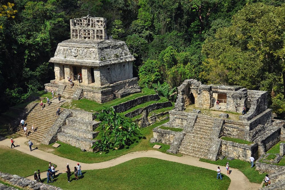
Palenque, an important Mayan city-state, flourished during the reign of Pascal the Great in the seventh century. but sadly now entirely lost. The beauty of its buildings and sculptures is what draws visitors there. Around the year 1120, the jungle took back the abandoned village and buried 90% of it under its thick growth.
Contrary to the norm for Maya settlements, Palenque was designed around a royal palace rather than a religious building. The palace is one of the most complex pieces of architecture at any Maya site. It was likely started by Pakal, and it got big additions like the tower around 721 CE. The structure measures 91 x 73 meters and is perched on a 10-meter-high platform with rooms arranged around internal courtyards and halls with vaulted ceilings.
The square, four-story tower of the palace stands out because it is another feature that you don’t often see in Mesoamerican buildings. A stairwell that looped around the inner walls allowed access to the tower’s upper levels and its impressive 25-meter height. The palace served not only as the royal family’s home and court but also as quarters for nobility, staff, and soldiers.
There is also a room with hot water, two bathrooms built over an underground stream, and many reliefs for prisoners. The inside of the palace was also lavishly decorated with brightly colored stucco paintings that showed scenes of Maya royalty. The pyramid, which was built into a hillside and completed around 682 CE, contains nine stories, which likely correspond to the nine levels of the Maya Underworld. In 1952 CE, while conducting an archaeological study at the pyramid’s summit, Mexican archaeologist Alberto Ruz famously discovered that a single oddly holed block in the flooring of one chamber could be lifted, revealing a staircase that led down into the building’s center.
After clearing away the intentionally left wreckage and venturing deep inside the pyramid, Ruz discovered a single corbel-roofed chamber at the bottom of the spiraling 65-step staircase, outside of which were five or six human skeletons, almost certainly sacrificial victims. It was obvious that this was the final resting place of a significant person. There were nine stucco attendants on the sloping walls of the lavishly adorned crypt, and two more in jade stood before the room’s most spectacular artifact.
10. Lothal, Gujrat, India
Lothal, one of the world’s most significant long-lost cities, still demonstrates the Indus Valley Civilization’s mastery of city planning and organized buildings. This was one of India’s historic cities that disappeared without a trace. All of these ancient civilizations ended too soon because of Mother Nature, and all that’s left of them now are crumbling ruins and broken buildings that tell of their once-proud histories.
The city of Lothal became famous because of its thriving bead industry. People say that the Lothalans had very advanced ways of making beads and that these methods haven’t changed much in the last four thousand years. The dockyard in Lothal made sure that the town was close to the water and had strong trade and business connections with other major urban hubs.
Copper and semiprecious stones were just two of the many types of raw materials that Lothal often brought in. Furthermore, the ancient city was a major hub for the production of shell accessories. Because Lothal was close to the Gulf of Kutch, its people had easy access to a wide variety of shells, which they used to make unique jewelry, tools for fishing, and even weapons.
In a similar way, the city’s export business links went to a lot of other cities. Egypt, Bahrain, and Sumer have all yielded Lothal-specific artifacts. In addition, in Mesopotamia, researchers uncovered unique beads that could only have come from Lothal. All of these pieces of evidence show that Lothal participated in international trade.
Lothal’s demise and the lost and found remains, can be attributed to the city’s location so close to the ocean. Despite being hit by a number of floods and storms, the city was always swift to restore its infrastructure. Over time, though, as the town and its economy grew, they weren’t able to keep up with the repairs (maybe because they had too much faith in their own system and architecture), and the city started to fall apart. As residents left, commerce slowed and customers went elsewhere, the city’s infrastructure continued to deteriorate, and floods caused further damage.
11. Iran’s Persepolis reliefs
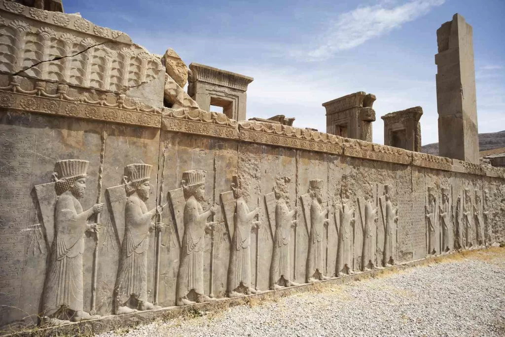
Darius1 started building the beautiful city of Persepolis in 518 BC. It took more than a hundred years to finish. This ceremonial capital of the Achaemenid Empire is located in Fars Province, Iran, some 60 kilometers northeast of the city of Shiraz. When one first steps through the enormous Gate of All Nations, one cannot help but be impressed.
Though now abandoned and the true essence lost, you first see a large terrace with intricate carvings of slaves, kings, bureaucrats, and people from the huge Persian empire all around you. During the height of the Persian Empire, when the bas-reliefs of Persepolis were sculpted, the country was at the pinnacle of its strength and influence. In 559 B.C., Cyrus the Great overthrew the ruler of the Median Empire because he didn’t like how powerful it was getting.
He then started the Persian Empire and quickly made it stronger. At the height of his power, Cyrus’s great-grandnephew Darius the Great had expanded the Persian Empire to include much of what is now Western and Central Asia, as well as the Indian subcontinent as far south as the Indus Valley. In 515 B.C., as befitting such a vast empire, the first stones were laid for what would become Persepolis, a brand-new metropolis in the mountains of what is now Iran. It was too far away to be the center of government, so instead, it was used for big ceremonies, like welcoming dignitaries and celebrating the Persian New Year, Nowruz.
Even though Cyrus chose the site, it was Darius who was in charge of planning and building the most important buildings for the Persian Empire. He hired sculptors to decorate the outside of these buildings with elaborate sculptures and many bas-reliefs. Persians’ history was mostly told orally and through pictures, but it was also written down and carved into rocks. Even today, people can learn about the once-great society by looking at the beautiful bas-reliefs that told the story to ancient visitors.
12. Cambodia’s Angkor Wat and its Hindu sculptures
Many people think that the Angkor complex, which is made up of several former Khmer capitals, is one of the most impressive historical sites in the world. With an area of nearly 400 square kilometers, this ancient metropolis is truly enormous. The Cambodian temple complex of Angkor Wat in the city of Siem Reap is the largest such structure in the world. Angkor Wat means “city temple” in Khmer, Cambodia’s national language.
It wasn’t always called Angkor Wat, even back when it was first constructed in the 12th century. Even though Angkor Wat is the biggest religious building project in Southeast Asia, there are no documents or inscriptions that name the temple. This makes it hard to figure out what it was called when it was in use. Now although lost, the Hindu temple Angkor Wat stands out as the best in the area due to its awe-inspiring fir-cone towers, stylized statues of human faces, and intricately carved reliefs depicting Hindu mythology.
There are eight different Hindu legends depicted in Angkor Wat’s 1,200 square meters of carved bas-reliefs. Perhaps the most significant story told at Angkor Wat is the one depicted in the Churning of the Ocean of Milk (below), which tells of the beginning of time and the birth of the universe. Additionally, it is a tale of good prevailing over evil. In the story, the devas (gods) are fighting the asuras (demons) to bring order and power back to the gods.
The milky sea is being churned by the opposing forces, as shown in this relief. As shown in the upper figure, the Naga, or serpent monarch, acts as a divine rope for the gods and demons as they engage in a game of heavenly tug-of-war. Mt. Mandara, which stands for Vishnu, is where the Naga is being whirled (in the center). While milk is being churned, a number of processes occur.
For example, the foam created by the churning is used to create the apsaras, or celestial maidens, that can be found in relief carvings all over Angkor Wat (we see them here on either side of Vishnu, above the gods and demons). Immediately after the elixir is let out, the Vedic god Indra (the monarch of all the gods) is depicted swooping down from the heavens to grab it and save the world from the demons.
For a long time, nobody knew what brought the Angkorian empire down in the early 15th century. Recent investigations, on the other hand, have shown that the city fell because its infrastructure was badly damaged by heavy monsoon rains that came after a long drought in the area.
13. Mari the First Planned City Stands Lost
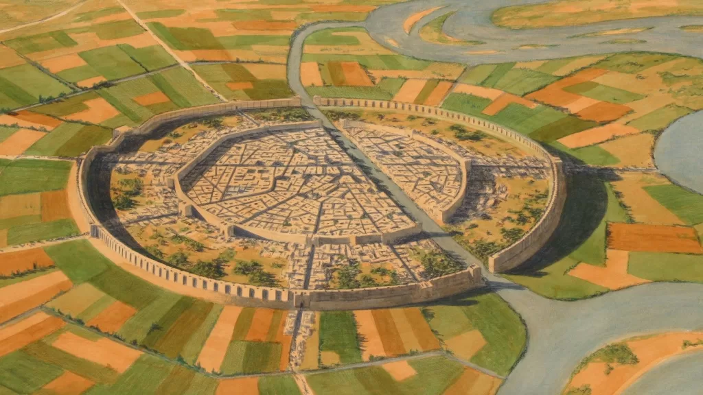
From its location choice to its street grid, Mari was likely the first city to be meticulously planned. The first investment was in the shape of a circle and had a wall around it to keep out floods and invaders. There are three stacked cities on the land. From about 2900 BCE (or 3100 BCE, according to certain sources) until its destruction by Hammurabi of Babylonia around 1760 BCE, it thrived. After that, small villages stayed until about 600 CE. After that, the history and memory of Mari faded.
It was on the west bank of the Euphrates, which made it a great place for trade between the many Bronze Age cities and states. Copper and tin, which are needed to make bronze, could be found in the Taurus Mountains. Archaeological excavations at Mari Tel al-Hariri uncovered a bronze and other metal smelting facility. Both domesticated animals and fertile farmland were used to keep the caravan trade and river trade going.
Now being lost the city managed two major waterways. Water for both urban and agricultural uses came from a single canal. It traversed the urban area. Toll sluices on the second canal, which was 120 km (about 75 miles) long, let ships avoid the Euphrates’ rapids and snaky turns.
It was found in the 1930s by Bedouins who were digging graves. Since 1933, archaeologists have been digging there. King lists from Sumer, which date back to 2084 BCE, feature the third city of Mari’s rulers. Zimri-New Lim’s palace (1779–1757 BCE) has more than 300 rooms, hallways, and gardens. Around 25,000 Akkadian-language clay tablets dating from between 1796 and 1757 BCE have been uncovered. These rulers were the Semitic Amorites. However, the city’s trade associations contributed to its cultural diversity.
Forty-two excavations have made Mari the best-understood ancient Near Eastern city, and Unesco has included it on its World Heritage List because of this. Drone footage from the year 2020 shows widespread destruction and theft as a result of the terrorist battles that broke out in 2011. The area is still inaccessible owing to landmines. It was at its peak as a trading hub and dominant state between 2900 and 1759 B.C.
As such, it was strategically located in the center of the Euphrates trade routes, connecting southern Sumer with the western Eblaite kingdom and the Levant. The Marriot’s built an important commercial hub where they worshipped both Semitic and Sumerian gods. Mari was not a city of Sumerian immigrants, but of Semitic-speaking people whose language was similar to Eblaite. This influence was strongest in the time before the Amorites came.
Mari now lost, was abandoned around the middle of the 26th century B.C., but by the time the East Semitic states had a strong leader, the capital city, Mari, had been rebuilt. The Second Mari fought a long war with its adversary Ebla and is sometimes compared to Sumer due to their shared cultural heritage. After the Akkadians destroyed it in the 23rd century BC, a military leader took over and let the city be rebuilt (Shakkanakku).
In the wake of the collapse of the Akkadian Empire, the city’s administrators took control and remade it as a regional hub in the Euphrates Valley. The Shakkanakkus dynasty ruled Mari until sometime in the second half of the nineteenth century BC. A few years later, the Amorite Lim dynasty made Mari it’s capital. Even though Babylonia destroyed the Amorite city of Mari around 1761 BC, a small group of people still lived there during Babylonian and Assyrian rule. During the Hellenistic period, they were ignored and left to rot.
14. The Volcanic Aftermath of Akrotiri-A lost City

There are many myths and legends about the huge eruption of the Thera volcano around 1650 BCE. Dates between 1650 and 1550 BCE are used to accommodate a wide range of possibilities. We do know, though, that the once-bustling trade link between Cyprus, Crete, mainland Greece, the Levant, and many other places has been broken. Egypt and other Mediterranean countries have both produced ash.
The island’s heart disappeared under the water. Several other islands and Minoan communities on Crete were wiped out by earthquakes and tsunamis. In the eighth century BCE, the Dorians moved back into what was left of Thera. During the Hellenistic period, the Ptolemies used the island as a naval base. Akrotiri, a city on Santorini that is 3,600 years old and was covered in ash after a huge volcanic eruption in 1650 BC, is a fascinating time capsule for modern archaeologists who are slowly putting together the lives of the mysterious Bronze Age people who lived there.
The city was part of the Minoan civilization, which flourished both on the Greek island of Thira (named after its mythical ruler, Theras) and on the neighboring island of Crete. An entire city-state, discovered by archaeologists to have been part of the Minoan civilization, was wiped out when the island, previously known as “Stronghili,” or “round,” erupted. Ancient writings say that the ash cloud made by the island of Thira’s ruins circled the Earth for two years, causing a period of cooling around the world.
The island of Santorini, with its colorfully trimmed three- and four-story buildings and public art (including frescoes) that attest to a sophisticated civilization, raises the intriguing possibility that it was the legendary Atlantis, the city of great beauty that was lost to the sea. Plato said that the people of Santorini would be punished for being too proud a thousand years before the Acropolis was built. The evidence is growing that this may be the case, although the question may never be answered to everyone’s satisfaction.
Stunning Santorinian ceramic sherds were discovered during excavations in 2020. Image courtesy of the Greek Ministry of Culture The island that Plato talks about in “Timaeus” and “Critias” was once a major military power, but its people got so proud that the gods destroyed the city as a punishment for them. The great ancient Greek philosopher Heraclitus claimed that Athens had previously been besieged by the city’s naval forces, but the Athenians had successfully withstood the onslaught. The city-state was then punished by the gods for its arrogance by disappearing beneath the seas of the Aegean.
Fine frescoes and many other artworks and objects were well-preserved thanks to the city’s entire burial in volcanic ash, similar to what happened later at the city of Pompeii near Italy’s Mt. Vesuvius. Because of the way the incident froze time, we can now see the city as its inhabitants last saw it. Because of the way the incident froze time, we can now see the city as its inhabitants last saw it. Archaeological evidence indicates that a sizable earthquake occurred and that many residents subsequently returned to begin making repairs to their homes. Unfortunately, the earthquake was just a sign of what was to come a few days later: a huge volcanic eruption.
Note: In this episode, we have added another 7 great cities that have been lost to us, and we can only now see the ruins and marvel at how magnificent our ancestors were. Part -3 of our upcoming episode will take you through a few more amazing sites that have vanished.
Disclaimer:
The author’s views are his or her own. The facts and opinions in the article have been taken from various articles and commentaries available in the online media and Eastside Writers does not take any responsibility or obligation for them.
Note: Contact our Writers at www.eastsidewriters.com for writing Blogs/Articles on any niche. We have experts in various domains from Technology to Finance and from Spirituality to Lifestyle and Entertainment.


Pingback: Explore 25 Lost And Forgotten Cities Of The World- Part 3 - Eastside Writers