The final episode of “Explore 25 Lost and Forgotten Cities of the World” will guide you through the remaining five lost and forgotten cities of the world, following the first three episodes. These beautiful, awe-inspiring places showed that our ancestors were just as rich as we are and, in some ways, better than us at landscaping and building cities with few resources. Thus, this extravaganza of a series has shown that once vibrant and healthy cities were fantastic places for business, religion, and humanity to grow. However, the wrath of nature has brought it to its current state.
Let us explore without further ado.
20. Ani, Turkey: one of the world’s greatest vanished city

In the tenth century, when Ani was the beautiful capital of an Armenian kingdom, it was known as “The City of a Thousand Churches.” And many of them are still there, seeming eerily out of place in the lush meadows that surround them. Once, these impressive ruins were part of a city-state that could have been on par with Damascus or Constantinople, but now they are almost forgotten.
On the Turkish side of the Akhurian River, across from Armenia, you can see the ruins of Ani, which was once a thriving metropolis known as “the city of a thousand and one churches.” Ani, which was founded more than 1,600 years ago and is located on multiple trade routes, grew to become a walled metropolis of over 100,000 people by the 11th century.
Byzantine emperors, Ottoman Turks, Armenians, nomad Kurds, Georgians, and Russians were just some of the people who claimed and lost Ani and the surrounding land hundreds of times over the next few hundred years. They kept coming in and driving people out. Ani began a rapid fall in the 1300s, and by the 1700s, it had been completely deserted. many cities were rediscovered and idealized in the nineteenth century, enjoying a brief period of prominence before being cut off by World War I and the subsequent events of the Armenian Genocide, which rendered the area a desolate, military wasteland.
The ruins fell victim to a variety of destructive forces, including human hands (looters, vandals, and Turks who tried to erase Armenian history from the area), archaeological hands (clumsy digs), good hearts (poor restoration attempts), and the forces of nature (natural erosion, flooding, and collapse). These pictures were taken after a decade of loosening travel restrictions to Ani.
Ashot III the Merciful (reigned 952-977), the Bagratid king of Armenia, moved his capital from Kars to Ani in 961. This wealthy town first became known in the 5th century AD because it was on a key east-west caravan route. Under the administration of the two following Bagratid dynasties, the city entered a period of great prosperity and splendor. Many magnificent specimens of medieval church architecture were erected there at this time.
Anni was big and beautiful, but the Middle Ages’ estimate that there were around 100,000 people there in the early 1100s is at best questionable. The city was the capital of Armenia until the 13th century when it was destroyed by Mongol invasions, a big earthquake in 1319, and changes in trade routes. Finally, the location was determined. The churches and parts of the city walls that are still standing show how good Armenian stonework was in the Middle Ages. In close proximity lies the trendy Turkish town of Ocak.
From their inception in 922 with Ashot II the Iron, the Bagratids of Ani held the title of shahanshah (lit. “king of kings”), bestowed by the caliph. The Bagratid kingdom of Kars was established in 961 by Mushegh, the younger brother of Ashot III. What little was left of the Bagratids and the Armenian kingdom was wiped out by the combined invasions of the Seljuk Turks and the western conquests of the Byzantine Empire in the 11th century.
21. La Ciudad Perdida, deserted city

Ciudad Perdida, or “The Lost City,” was the cultural center of the Tayrona civilization, which had settlements all along the Colombian coast and was at least six centuries older than Machu Picchu. In the 650 years before the construction of Machu Picchu by the Incas, another culture was also busy constructing its own city of gold. The era of the Tayrona began as the Caribbean Sea began lapping along the coast of northern Colombia.
It was the year 800 AD when the Tayrona began constructing Teyuna in the steamy forests of the enormous pyramid that is the Sierra Nevada. It’s currently referred to as “the Lost City” or “La Ciudad Perdida.” Teyuna was the beating center of a cluster of smaller cities that dotted the slopes and valleys of the world’s highest coastal mountains. Over 5,700 meters (18,700 feet) in elevation, the Sierra Nevada rises majestically above rainforests that reach all the way to the ocean. In the shadow of these ice-capped giants, priests, craftspeople, and soldiers worked to move civilization forward.
It is estimated that La Ciudad Perdida had a population of between 4,000 and 10,000 people and covered an area of more than 12,000,000 square feet (129,167 square feet). Because they were connected by bridges and drainage systems, the buildings were able to stand up to the effects of time, tropical rain, and the growth of the jungle.
Teyuna was abandoned when Spanish conquistadors arrived on Colombia’s coasts. Bringing smallpox and syphilis into the Tayrona realm helped silence the rest of the culture. The timber, rocks, and trails were all recovered by the jungle. No one saw the city for 350 years, except for the occasional native who kept an eye out. Then, in 1972, a group of guys on a bird-watching expedition near the Buritaca River came across a set of mossy steps climbing up a rocky ridge.
They tore back the foliage and yanked away the vines. They all seemed to have come down with a fever. The rainbow plumage of tropical birds was no longer sufficient. They were on the lookout for a different hue. Through chopping and smashing, they made their way to the platforms that had once served as homes.
Also, you could find tombs close to the dwellings. They made extensive holes in the ground. That’s when they started raiding tombs. Satiation came in the form of the glimmer of a metal that has fueled hopes, ambitions, and journeys to the far reaches of the globe at times when people weren’t sure whether they were about to vanish off the face of the planet.
There are 1,200 mossy stone steps leading up from the Buritaca River to the city. You may reach the 169 stone terraces that makeup La Ciudad Perdida by following this trail. There are 3,000 square meters to explore at this location. The city’s many buildings include homes, plazas, ceremonial spaces, stone-lined pathways, stairwells, canals, and warehouses. In the middle of the ruins is a platform used for rituals. It can be reached by a spiral staircase. Teyuna is known for its one-of-a-kind architectural design.
22. city of Taxila in Pakistan

Taxila, now in what is now Pakistan, was a major city among the cities in ancient India and the hub of a powerful Buddhist culture. To this day, it remains one of the subcontinent’s most prized possessions. Few people travel to Pakistan, primarily due to concerns about their safety. However, the country is full of contrasts, and people who visit fall in love with the beautiful South Asian nation almost immediately.
Taxila, also called Takshashila, in Hindu Texts and Hindu scriptures is one of three cities that no longer exists. It was built by an ancient Indian ruler in the seventh century BCE, but it was destroyed soon after. The original structure stood on a hill that became known as Bhir Mound. A second Taxila, named Sirkap, which was set up by Greek invaders, took over the city.
This happened because of a complicated web of beats and political intrigue that sounds like something out of the Old Testament. When the Kushans took over Taxila and turned it into Sirsukh, they continued the city’s rich history in philosophy and the arts. In the sixth century, the city along with a few more cities fell to the Huns, who razed it to the ground.
The present-day location is around 19 miles (30 km) northwest of Islamabad. The Taxila Museum is filled with artifacts from all walks of life that shed light on the city’s tumultuous past. Buddhist writings from India, Greece, Rome, and China all talk about the city of Taxila (). Its name in the Urdu language means “City of Cut Stone.” The Indian epic Ramayana says that the Pandavas built the city. It was named after its first king, Taksha, who was the son of Barata.
Moreover, this is the original site where the Mahabharata was read aloud. After that, Buddhist texts mentioned the city as the capital of the Gandhara kingdom and a major intellectual center. hub. When Alexander the Great entered India, the country’s rulers adopted a Greek mentality. He heard that Taxila was a thriving and well-governed city at the time.
However, Taxila’s glory and global renown were short-lived. Its strategic location near Central Asia made it an easy target. Northern and Western invaders and attacks became commonplace. Just as its civilization had reached its pinnacle of success, the city was on the verge of collapse. The Greeks had already killed Taxila, but the Huns did it again. This led to a drop in population, which killed the city.
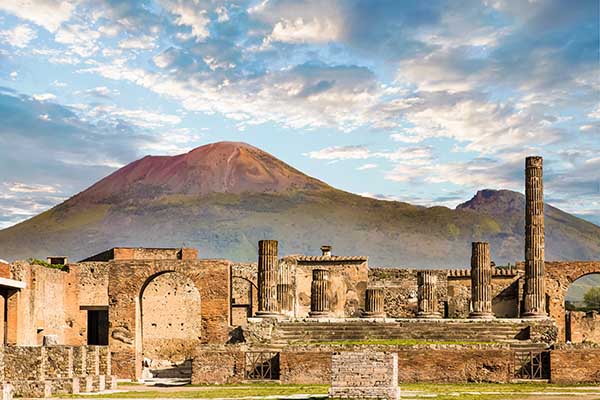
23. Pompeii and Herculaneum, Italy’s long-lost historic cities

A wave of ash from the 79 AD eruption of Mount Vesuvius buried the city of Pompeii. Numerous locals were buried alive alongside their pets and belongings, ensuring their preservation. Doors, food, and even furniture are all still intact at the nearby Herculaneum, which was evacuated in time but buried deeper under the ash. As a whole, they form a spooky time capsule of sorts. The ancient city of Herculaneum in Campania, Italy, was home to between four and five thousand people.
It was 8 kilometers (5.0 miles) southeast of Naples, at the western base of Mount Vesuvius. Along with Pompeii, Torre Annunziata, and Stabiae, it was destroyed in the year 79 CE. Part of the area is now covered by the town of Ercolano, which is expected to have 51,600 people by the year 2021. Digs at ancient cities like Herculaneum and Pompeii in the middle of the 18th century paved the way for the contemporary discipline of archaeology. In 1997, the tower of Annunziata and the ancient cities of Pompeii and Herculaneum were named UNESCO World Heritage sites.
It was 8 kilometers (5.0 miles) southeast of Naples, at the western base of Mount Vesuvius. Along with Pompeii, Torre Annunziata, and Stabiae, it was destroyed in the year 79 CE. Now that a core of the Oscan-speaking part of the area is now covered by the town of Ercolano, which is expected to have 51,600 people by the year 2021, The Samnites dominated Herculaneum in the 4th century BCE. After losing the “War of the Allies” (Social War) against Rome in 89 BCE at the hands of Titus Didius, a legate of Lucius Cornelius Sulla, the city was taken over by Rome and made into a municipium.
An earthquake in 62 CE did a lot of damage to both public and private buildings in Herculaneum. The cities had not yet recovered when it was buried by the Vesuvius eruption on August 24 and 25, 79 CE. Early excavations found few human remains, which led some to think that, unlike the people of Pompeii, the people of Herculaneum had been able to escape the ash and pumice rain in the opposite direction, toward the city of Naples.
In the 1980s, though, more than 120 human skeletons were found during excavations along the old shoreline of the Bay of Naples, which is now inland. This shows that many more people died trying to leave the area and the cities where they lived. In the 1980s, though, more than 120 human skeletons were found during excavations along the old shoreline of the Bay of Naples, which is now inland. This shows that many more people died trying to leave the area.
Public monuments found include a palaestra, which is a sports field with a large portico surrounding a large central piscina, and a number of thermae, which are baths. One of the thermae is next to the site of the old beachfront and is in surprisingly good shape because it was not affected by the pyroclastic flows that came with the eruption.
24. Carthage, Tunisia, an ancient seaport city
The Roman Empire destroyed and then rebuilt Carthage, which was once the center of trade for the Phoenicians. Over time, this location became the Carthaginian civilization’s capital and a thriving port city. This long-lost metropolis rivaled Rome in size during its heyday. A great ancient city on Africa’s north coast, now a residential district of Tunis, Tunisia, it is known in Phoenician as Kart-hadasht and in Latin as Carthago.
It was constructed on a rocky outcrop off the coast of Tunisia so that it could keep an eye on and perhaps control Mediterranean shipping lanes between Sicily and the North African coast. Because Alexandria grew quickly as a port and trading center, it became a major power in the Mediterranean and Rome’s main rival in the area. In 1979, UNESCO put Carthage on its list of ancient cities and sites that are part of the World Heritage List. living life as the major cities of the classical world
Carthage dominated the West’s trade in murex shells, which were used to create a sumptuous purple dye, but the Punic world was more interested in commerce than art. When the Romans destroyed Carthage, they either burned down or gave away the city’s libraries and archives. This means that any arguments about the lack of Punic literature are pointless. The Romans thought that beds and furniture made with Punic joinery were very nice, so they copied their designs. This was the specialty of the cities at that time.
As early as 800 BCE near Gadir (modern Cádiz, Spain), and in the 3rd century BCE near what is now Cartagena, Spain, Carthage began exploiting the silver mines of North Africa and southern Spain. Carthage and Rome fought multiple wars beginning in the second century BCE and lasting until the middle of the third century.
The result of these wars, which are known as the Punic Wars, was that Rome completely beat Carthage and grew its power in the Mediterranean. The demand of senator and orator Cato the Elder, summed up in the phrase delenda est Carthago, “Carthage must be destroyed,” was met when Carthage fell in 146 BCE and the city was sacked and burned. For the Carthaginian era in North Africa, see there as well.
25. City of the Roanoke Colony in North Carolina
Sir Walter Raleigh led the first colonists to Roanoke Island, which is near the coast of North Carolina today. After losing touch with the colonists for three years, Governor John White eventually made his way back to Roanoke Island from England in 1590. Both the settlement’s buildings and the town’s population of a hundred or more had mysteriously vanished. The only hints were the letters “Cro” and “atoan” etched into a tree and a post, respectively.
Founded by Sir Walter Raleigh, the Roanoke Colony was a forerunner to modern-day North Carolina’s colonial settlements on the mainland. Following a three-year separation from the colonists, Governor John White returned to Roanoke Island from England in 1590. Not only were all of the settlement’s buildings abandoned but so too were the town’s hundred-plus inhabitants. A post with the word “Croatoan” carved into it was the lone hint, and a tree with the letter “Cro” etched into it was the only other piece of information.
In 1585, Sir Walter Raleigh led an expedition to Roanoke Island, located off the coast of modern-day North Carolina, to establish a colonial settlement. A three-year separation from the colonists resulted in Governor John White’s return to Roanoke Island from England in 1590. All of the town’s structures were abandoned, and the town’s population of 100 had mysteriously vanished. The only hints were the letters “Cro” and “atoan” etched into two separate posts and a tree, respectively.
A tiny settlement was established in 1587 on a remote island off the coast of North America. If the colonists had not vanished for reasons we will never know, the settlement would have been the first permanent English colony in the New World. The mysterious disappearance of the Roanoke colony and the subsequent proliferation of conspiracy theories about its whereabouts have made it one of the most famous unsolved mysteries in U.S. history.
To get the town the help and supplies it needed in its first, tough year, Mayor John White traveled to England. After three years, he went back to the village only to discover that his family had vanished along with the first English kid born in the Americas. Within the bounds of the colony, the only clues were the word CROATOAN and the initials CRO etched into trees. A storm rolled in just as the returning crew discovered the abandoned hamlet, so they had to turn around and head back to England despite the evidence that had been left behind.
Many people believe the colonists relocated to what was then Croatoan Island which is now called Hatteras Island based on a mystery tree carving. Hatteras Indians lived on the island when the colony was founded, and one popular narrative suggests that the colonists allied with the Native Americans to help them survive.
Eleanor Dare, John White’s daughter, is said to have carved symbols onto stones, which could lend credence to the claim. The Dare Stones are a collection of written stories and anecdotes passed down from Dare to her father that detail the plight of the colonists. Despite widespread skepticism, at least one scholarly opinion holds that the stones might be real.
The Croatoan Project has been doing research and presenting archaeological data since 1998 in support of the notion that the colonists relocated to live with or at least have contact with the Hatteras tribe. The link between the two groups was confirmed by the discovery of artifacts and things in Croatoan settlements that could only have been possessed or created by English settlers at the time. But even with this and other possibilities, it is unlikely that the colonists’ disappearance will ever be solved.
People have thought that the colonists might have died on the sea, at the hands of cannibalistic natives, or at the hands of the Spanish, among other things. The Lost Colony Center for Science and Research in Williamsburg, Virginia, is conducting The Lost Colony DNA Project in the hopes of locating living descendants of the colonists who went missing.
Disclaimer:
The author’s views are his or her own. The facts and opinions in the article have been taken from various articles and commentaries available in the online media and Eastside Writers does not take any responsibility or obligation for them.
Note: Contact our Writers at www.eastsidewriters.com for writing Blogs/Articles on any niche. We have experts in various domains from Technology to Finance and from Spirituality to Lifestyle and Entertainment.